
Landscape position and slope affect water movement across a site and through the soil. Thus, an understanding of slope and landscape position is critical in predicting water flow and site suitability for on-site system placement. Wellpositioned on-site systems ensure that water is drained away from the site and that an adequate depth of aerated soil (12 - 18 inches) is maintained under the treatment and disposal trenches.
Relief, which includes slope and landscape position, is one of the five soil-forming factors that, along with climate, organisms, parent material and time, affect the soil's characteristics. Relief bas a pronounced effect on the soil type and depth, characteristics that are critical in determining the suitability of a site for the placement of an on-site system.
Slope and topography.
Slope refers to the inclination of the land surface whereas topography refers to the physical features of an area of land, especially the surface configuration.
The topography of an area can be described as hilly, mountainous, flat, or as a coastal plain, foothills, piedmont terrain, plateau, or mountain ridges. Topography can be simple, such as in areas with smooth land surfaces, or complex, such as in areas that have abruptly irregular land surfaces. For example, contours of elevation, and the shapes of hills, mountains, valleys, ravines, streams, and rivers are shown on a topographic map.
Conventional on-site systems can be installed on slope from 0-65%. The shape of the slope at a specific site is also important. For example, a site on a slope may have an outward or convex curve, which is a good placement site, or an inward or concave curve, which is a poor placement site.
Landscape position.
Landscape position is the specific position on a topographic feature. For example, an area may have a billy topography and the landscape position of an on-site system may be at the bottom of one hill in the area. The landscape position of the treatment and disposal field is critical to the performance of an on-site system.
Slope and landscape position.
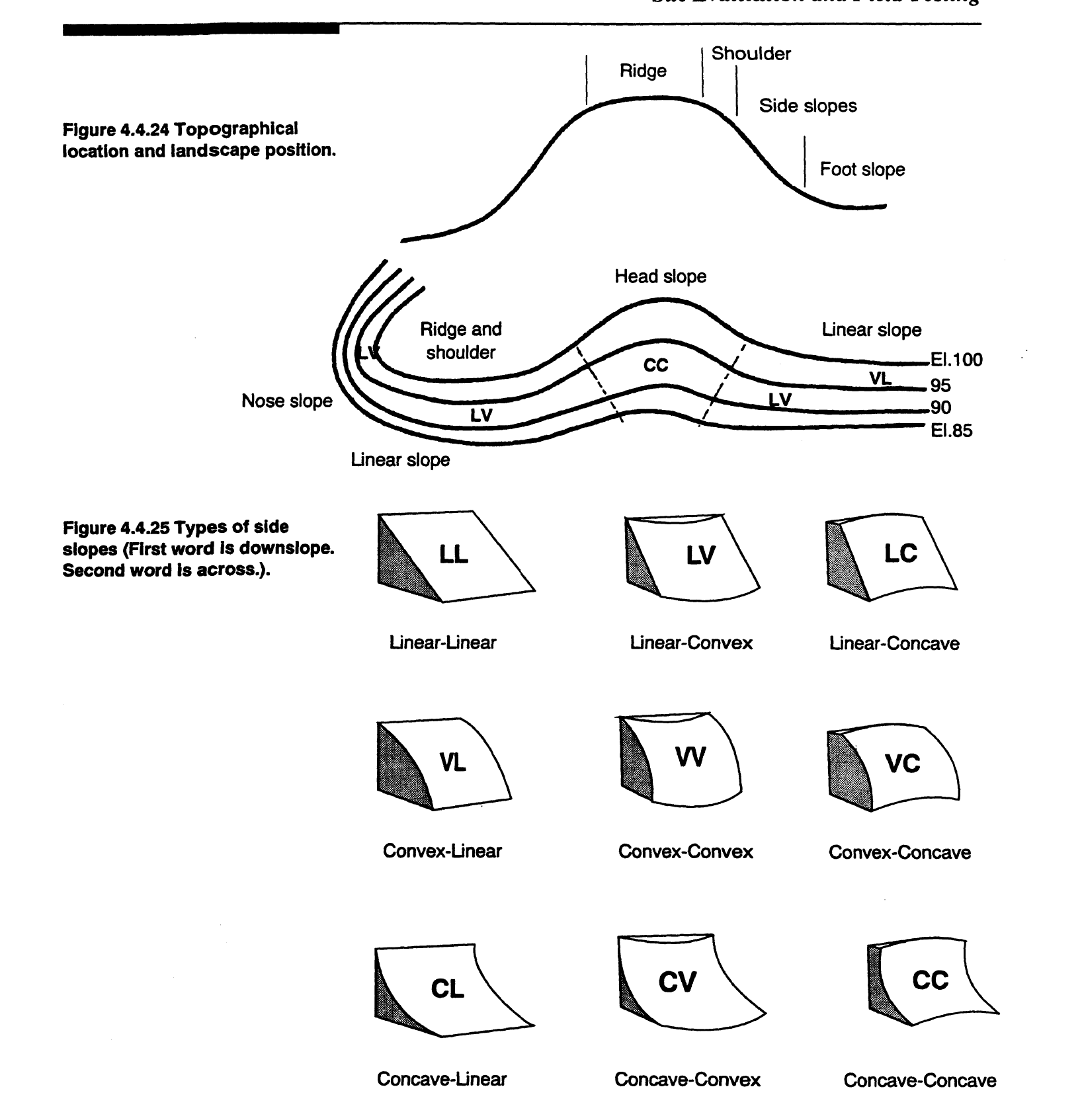
Figure 4.4.24 shows the different landscape positions: interfluve or ridgetop, shoulder slope, side slope, foot slope, and toe slope.
1. The interfluve, or ridgetop, is the flat area between streams. If the distance between the streams is large then the area is called the interfluve. Conversely, if the distance is small then the flat area is the ridgetop.
2. The shoulder slope is the landscape position adjacent to the interfluve, where the flat areas begin to break into a slope. This slope is concave and water runs off without accumulating in the soil.
3. Side slopes have nine distinct slope types: linear-linear, linear-convex, linearconcave, convex-linear, convex-convex, convex-concave, concave-linear, concave-convex, and concave-concave (Figure 4.4.25).
Linear slopes follow a straight line down the slope but may be flat or curve across the slope, in the horizontal direction. If the land follows a straight line down the slope and across the slope, then it is called linear/ linear. If the linear slope curves outward across the slope it is linear/ convex, and if it curves inward it is linear/concave.
More runoff flows away from the site on linear/linear and linear/convex slopes than on linear/concave slopes. This means that less water accumulates in the soil on linear/linear and linear/convex slopes than on linear/concave slopes.
Topographical location and landscape position
4. Toward the bottom of the slope is the foot slope and the flatter toe slope. This is where colluvium, soils formed from debris moving down the hill, and alluvium, soils formed from deposits of sediment from streams, are found. The toe and foot slopes have a concave shape in the vertical direction and are often poorly drained.
Landscape position and slope in siting on-site systems.
Because slope and landscape position have pronounced effects on the soil type, soil depth, and drainage, these factors are extremely important in site evaluations for on-site systems. However, slope and landscape position must always be evaluated at each site because soil conditions and drainage differ in different regions. The following points indicate how slope and landscape positions should be used for site evaluations.
Land with a uniform slope less than 15% is considered to be SUIT ABLE for on-site systems.
If the topography is such that the land has a uniform slope between 15 and 30%, then that land is considered PROVISIONALLY SUITABLE for on-site systems.
For land with a slope greater than 30%, the land is classified as UNSUITABLE unless an investigation shows that a modified conventional on-site system can be installed properly as under rule 15A NCAC lSA.1956.
Slopes greater than 65% are always classified as UNSUITABLE.
Topography where there are complex shapes to the slopes or many gullies and ravines cutting the slopes is considered UNSUITABLE for on-site systems.
Depressions, or bowl-shaped indentations in the land surface, usually are inappropriate sites for on-site systems and are classified as UNSUITABLE. Depressions collect water and are generally wetter than the surrounding soils, making them UNSUITABLE. However, if the site complies with other requirements and is approved by the local health department, the site may be considered SUITABLE.
Toe slopes, foot slopes, head slopes, and depressional areas are difficult landscape positions for siting septic systems because these locations are frequently not sufficiently drained.
Occasionally, there is a difference in the suitability of the same landscape position in the three geographic regions in North Carolina (fable 4.4.12). This is because the same landscape position in different regions has differing drainage. For example, although the interfluve position is an excellent location for on-site systems in the Piedmont and Mountains, it is a poor site in the Coastal Plain. Because the Coastal Plain is relatively flat and also because there is a restrictive layer that causes a shallow ground water table, soils in the interfluve region of the Coastal Plain are poorly drained and are generally UNSUITABLE for on-site systems. See Figure 4.2.3 for an illustration of this characteristic.

Landscape Position and On-Site System Siting Potential
From the North Carolina Onsite Guidance Manual