
Soils are characterized by the minerals and organic matter from which they are made and by the sequence of these mineral and organic layers. The type of soil layer and the order in which the soil is layered are extremely important in on-site systems because soil layers control the movement of wastewater through the soil into the ground water.
Soil Horizons
A soil consists of a number of layers roughly parallel to the earth surface. These layers are called soil horizons.
A soil horizon, as defined by the rules, “means a layer of soil, approximately parallel to the surface, that has distinct characteristics produced by soil forming processes.”
Soil horizons are identified by different morphological characteristics: texture, structure, color, or consistence. These are discussed in greater detail on page 4.4.8.
Soil scientists use a technical language in which each horizon is separated into one of six master horizons or layers. Master horizons are designated by the capital letters 0, A, E, B, C, and R where each master horizon indicates a certain set of properties in the soil. The sequence of horizons and horizon differentiation, for any given soil, is dependent on the soil forming factors. Figure 4.4.2 describes and demonstrates the six master horizons and their properties.
Every soil contains at least one master horizon, and some soils contain all six master horizons or layers. Usually a soil contains two or three master horizons.
The arrangement of horizons in the profile affects the rate of wastewater flow through the soil, the direction of flow (vertical or horizontal movement), and the amount of wastewater purification. Thus, the environmental health specialist must be able to identify the horizons present in the profile.
When horizons are transitional, that is, they have characteristics of both the overlying and underlying horizon, two master horizon symbols are used. For example, a BC horizon would indicate a transitional horizon that grades gradually from a B into a C but is more like a B horizon than a C horizon. On the other hand, a CB horizon would be more like a C horizon than a B horizon. When the "f' symbol is used it indicates that the transitional horizon contains identifiable pieces of both types of horizons. For example, a B/C horizon is indicative of a transitional horizon where the B and C horizons are intermixed and there is more B than C material. A C/B horizon would also be an intermixed transitional horizon but with more C material than B material. The BC or B/C horizons may be used for an on-site system if other soil factors are acceptable.
Master horizon designations can be modified by lower case letters that indicate subtle differences within a master horizon. Those symbols relevant to North Carolina soils are included in Table 4.4.1.
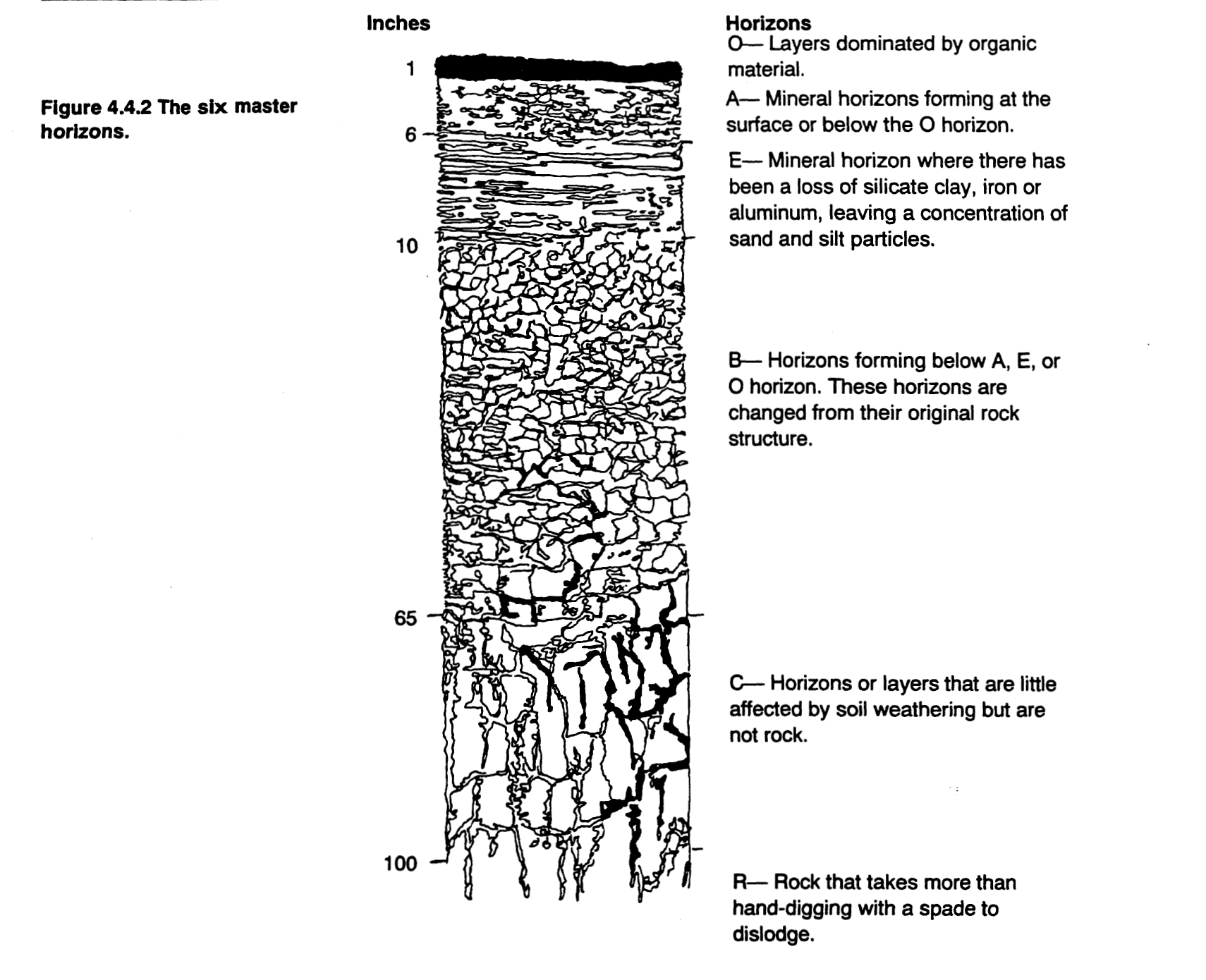
The six master horizons.
Some horizons allow water to flow through easily; other horizons obstruct water flow. Horizons which impede water flow are referred to as restrictive horizons. If a soil contains a restrictive horizon, the depth at which this horizon is located determines whether this soil is SUITABLE for an on-site system.
As defined by the rules (Ref. 15A NCAC 18A. 1935 (33)
“A restrictive horizon means a soil horizon that is capable of perching ground water or sewage effluent and that is brittle and strongly compacted or strongly cemented with iron, aluminum, silica, organic matter, or other compounds. Restrictive horizons may occur as frangipanis, iron pans or organic pans, and are recognized by their resistance in excavation or in using a soil auger”.

Subordinate Distinctions within Master Horizons
Other Morphological Properties of Horizons
Soil horizons can also be described by depth, thickness, and boundary conditions, as shown in Table 4.4.2.
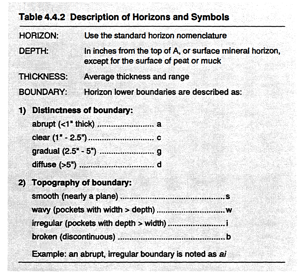
Description of Horizons and Symbols
Soil Profiles
Generally, a soil is composed of more than one horizon. If a hole or pit is dug in a soil, the horizons are uncovered for viewing. This vertical cross section of soil, where all horizons are revealed, is called a soil profile.
Soil profiles, showing typical arrangements of horizons for five representative soils in North Carolina, are presented below (Figure 4.4.3). These five soil profiles are but a few examples of the over two hundred types of soil profiles found throughout the state.
Soil Series
Soils can be grouped and classified based on the arrangement of soil properties within each layer in the soil profile. These properties include texture, temperature, wetness, mineralogical classes, organic matter content, and other characteristics.
Soil profiles that have a specific arrangement of horizons with specific characteristics in each horizon belong to a soil series. All soils in a soil series have similar profile characteristics. Each soil series will have developed from the same parent material with the same combination of weathering processes. The following concepts are helpful in understanding soil series.
Soils within the same soil series should be more alike and behave more similarly than soils in different soil series.
Soil series are generally named for a town or region near the location where the soil series is first described.
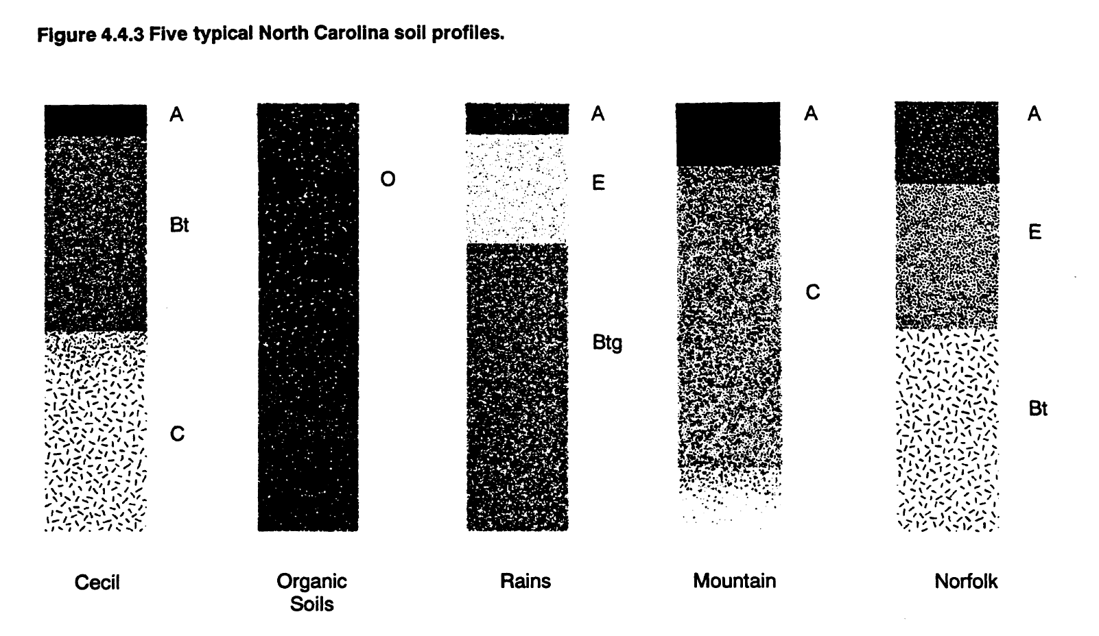
Five typical North Carolina soil profiles
Soil series are strongly associated with relief or topographic location. This is because the soil-forming processes and the other soil-forming factors (parent material, time, climate, and organisms) in a region are the same for one type of topographic location and so tend to form one or a few soil series from the same parent material. Catenas are a good example of the effects of topographic location on the landscape. A catena is a group of related soils in a topo-drainage sequence. A representative North Carolina Coastal Plain catena consists of five soil series: Norfolk, Goldsboro, Lynchburg, Rains, and Pantego. These soils are related by their topographic positions or relief. Relief affects drainage and thus the accumulation of organic matter. Norfolk soils are the most well drained, whereas Pantego soils are very poorly drained.
Soils are mapped as soil series. Because a soil series tells us about the properties of a soil, soil maps give a great deal of information about the soil and, consequently, they give a good idea of how an on-site system will function in a location with a given soil series. In North Carolina there are over 250 mapped soil series. Figure 4.4.4 is a representative soil map from the Piedmont area of North Carolina.
Because the scale of soil maps is generally greater than the area of an on-site system, soil maps should only be used in the initial survey of the area. The only reliable method for siting an on-site system in North Carolina is a thorough site and soil evaluation done by qualified specialist at the actual site. The site and soil evaluation must include a thorough evaluation of the soil morphological properties in the soil horizons at that location.
In North Carolina, each potential location for an on-site system is required, by law, to have a site and soil evaluation. Ref: G.S. 130(A)-336(b)
From the North Carolina Onsite Guidance Manual